Landsat Imagery
CalView Landsat Images
This directory contains Landsat images for the State of
California, as part of the CalView project. The images have all been
reprojected to the California Albers Projection, NAD 83 datum, and
provided in GeoTiff format.
The source Landsat image files upon which these images are based can
be accessed at a Landsat images http://casil.ucdavis.edu/casil/landsat5.usgs.gov.
The file naming convention of all CalView images is as follows:
l5_ppprrrYYYYMMDDbBB(B) where:
- l5 = Landsat-5 mission
- ppp = starting path of the product
- rrr = starting row of the product
- YYYYMMDD = acquisition date of the image
- BB = band
In the filename, the part containing l5_ppprrrYYYYMMDD is known as the
id of the image. The part after the id identifies the specific band(s)
of the image.
The monochromatic bands are: 10, 20, 30, 40, 50, 60, 70.
The composite bands are: 321 (true-color image) and 457 (false-color
image).
For instance: l5_4403420010930b60.tif describes a Landsat scene at
Path/Row 44034, acquired on September 30, 2001. This GeoTiff image
contains band 60 (infrared).
------
The CalView images can be accessed in several ways:
The user can quickly access all the images we have created by
accessing the "all":all subdirectory.
The user can also access the images via the following classifications:
- by_band - The images are organized according to one of the nine available bands. Composite images can also be accessed here
- by_id - The images are organized according to their id, as described above
- by_path_row - The images are first organized by their path/row, followed by the full date of when the images are acquired
- by_year - The images are organized by year. Currently the acquired images span between the years of 1999 and 2002, inclusive
Images composed of three bands (composite images) can be found in composite
Preview images for the GeoTiff images can be found in
preview. They are also included in the above
classification directories
A mosaic comprised of the CalView landsat images can be found in mosaic
For a comprehensive description of the Landsat Data Sets, please refer to
the following page:
Landsat Data Sets
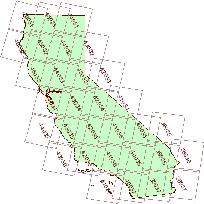
The following map illustrates CalView's Landsat coverage by Path/Row: